- Benz, Wolfgang, Salzgitter. Geschichte und Gegenwart einer deutschen Stadt, München 1992.
- Erhard Forndran, Die Stadt- und Industriegründungen Wolfsburg und Salzgitter, Frankfurt am Main 1984.
- Harlander, Tilman and Gerhard Fehl, Hitlers Sozialer Wohnungsbau 1940-1945, Wohnungspolitik, Baugestaltung und Siedlungsplanung, Hamburg 1986.
- Institut für Ur- und Frühgeschichte der Universität zu Köln und Braunschweigisches Landesmuseum, Der altsteinzeitliche Fundplatz Salzgitter-Lebenstedt, Köln 1982.
- Nerdinger, Winfried, Bauen im Nationalsozialismus. Bayern 1933-1945, München 1993.
- Sauer, Heiner and Hans-Otto Plumeyer, Der Salzgitter Report. Die zentrale Erfassungsstelle berichtet über Verbrechen im SED Staat, München 1991.
- Schönwalder, Hans Günter, Weerden und Wandel des Industriegebietes Salzgitter, Hamburg 1967.
- Schneider, Christian, Stadtgründung im dritten Reich. Wolfsburg und Salzgitter. Ideologie, Ressortpolitik, Repräsentation, München 1979.
- Thomson, Christian W, Gerd Winner, Berlin, London, New York, urbane Strukturen, München 1998. Troost, Gerdy and J.H.M. van der Eerden, Het bouwen in het Derde Rijk, Amsterdam 1943.
- Walz, Manfred, Wohnungsbau und Industrialisierungspolitik in Deutschland 1933 bis 1939, dargestellt am Aufbau des Industiekomplexes Wolfsburg, Braunschwieg, Salzgitter, Aachen 1978.
- Wysocki, Gerd, Zwangsarbeit im Stahlkonzern. Salzgitter und die Reichswerke ‘Herman Göring, 1937-1945, Braunsweig 1982.
type of New Town:
> scale of autonomy
New-Town-in-Town
Satellite
New Town
Company Town
> client
Private Corporation
Public Corporation
> policy
Capital
Decentralization
Industrialization
Resettlement
Economic
source:
Introduction
Salzgitter, formerly named 'Hermann Göring Stadt', is located in West-Germany, to the west of Wolfsburg near Braunschweig. After the assumption of power, Hitler wanted to improve the economical situation and put an end to the unemployment. He initiated employment works by laying out infrastructure and planning new residential area's. He also wanted to increase the use of raw materials and minerals from national ground, because most of the materials (70%) were until then imported from other countries. Herman Göring (1893-1946), a leading politicians during the National Socialist period and chief commissioner of raw materials and devises was assigned to plan a New Town with industry and 15,000 to 20,000 houses for 250,000 factory and mine workers. After studies of the German territory Salzgitter seemed to be the best location, because of the presence of minerals. In 1937 Herman Göring determined Salzgitter as new industrial area.
Urban plan and design
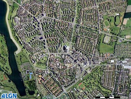
The urban plan was made by the architect of state buildings Herbert Rimpl (1902-1978). On the 5th of October he exhibited the plans to the government of Braunschweig for admission. The urban plan was formed by a half circular shaped ring road that separated the centre in the west of the settlement from the residential districts to the east. Rimpl chose a circular settlement to make the roads from the centre to the residential area of equal length. In the middle of the centre, on the Lichtenberger hill, Rimple designed a circular square with governmental and public buildings. Three main roads leaded from this square to the industrial area at the eastern side and connected Salzgitter with the highways to Braunschweig and Hamburg. The middle road, the East-West axis, leaded from the central square to a sports park with a stadium and was flanked by representative façades, just like Speer's monumental axis for the transformation of Berlin. The infrastructure was designed by Fritz Rechenberg, according to his publication of 1940. The residential districts consisted of a system of groups of houses that formed neighbourhoods and quarters with facilities, like schools and kindergarten, corresponding to the amount of inhabitants. This sub-division of the settlement was similar to the hierarchical political organization of the National Socialist political party.
Realization
The Umsiedlungsgesellschaft (Resettlement Society) started with the habitation of the workers from abroad. For the creation of new industries and residential cities most of the native inhabitants had to move, without any compensation for the greater part. In 1937 the first factory's (including a blast furnace and a power station) were constructed and barracks were built for the workers (93 for 7000 workers in four months). In the same year the first family houses with saddle roofs were built by the Hermann Göring Housing Association at the border of the existing villages. In total 19 types of two-storey high family houses with saddle roofs and small windows were planned. Most of the factory workers however could not afford the high costs of the houses - the prices were raised due to the market system - and had to keep living in the barracks. Most of the attention went however to the realization of the industrial area, building new residences was less important. In 1942 Albert Speer was charged to increase the production of Salzgitter industry as part of the 'Four Years Plan'. But this was impossible with the shrinking finances due to the war and the concentration on the production of war material. In 1943 finances stopped and a year later the construction of houses ended. Salszgitter-East was not realized according to Rimpl's plans. The first inhabitants did not have running water (no pipe lines) and electricity and the free market system caused high rents that the workers families could not afford. Streets were not paved and public services like hospitals, kindergarten, schools and public administration buildings were, except for one school-barrack, never built.
Present situation
After the war, factories were torn down because of security reasons and the West German government started repairing the area. The new residential area's, the old settlement, the shopping centre and Lebensted were connected to the infrastructure network. A new factory complex was built and the railway to Braunschweig was completed. In the period from the end of the war till 1961 18,736 houses were built. Since the sixties public services like a hospital, schools, swimming pools and sports clubs were built. A few years later damaged buildings and city districts were restored. But the planned city was never totally realized. Today Salzgitter has a surface of more than 223 square kilometer and more than 103,000 inhabitants.