|
|
Blanchardstown (Baile Bhlainséir), Ireland, Europe |
|
|
|
|
|
|
source: https://www.blanchardstow
ncentre.ie/background
|
Blanchardstown is a large commuter/sleeper town lying on the western outskirts of Dublin city. Prior to the 1970’s, Blanchardstown was a rural area with small villages dotting its landscape. The choice of the location of the town centre at Blanchardstown has its genesis in the Dublin City Development Plan of 1972. The esteemed British planner, Myles Wright, was commissioned to design new towns around Dublin city to alleviate the pressures of a growing population problem in the Irish capital. Other new towns included in this plan were Lucan, Clondalkin and Tallaght.
Contrary to normal practice of new town planning employed in the US and UK, the development plan did not create development corporations to spearhead their projects. Instead the burden and responsibility lay solely with the Dublin County Council. The council bought the land and provided all basic infrastructure and amenities such as water, sewerage, roads and green spaces. The Dublin Corporation, now Dublin City Council, also contributed by creating an extensive housing programme for the area. While national bodies were entrusted to provide amenities such as schools, public transport and areas for industrial activity.
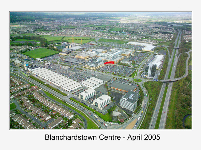
The Dublin City Development plan of 1972 foresaw Blanchardstown hosting up to 100,000 people. This plan has largely been realised with a current population of 93,000 and a planned capacity for over 150,000 residents. Blanchardstown, often shortened to Blanch by locals, is now a retail magnet which houses national and international brands in its modern American style shopping mall, Blanchardstown Shopping Centre. The centre is one of the largest shopping centres in the country. The town is also a major services provider in the areas of education, recreation and healthcare.
The private car was at the centre of the town’s development. This legacy reigns to this day with the vast majority of houses owning at least one car (79%). 55% of commuting journeys are made by car/van. The area sees lower than average active transport usage compared to other areas of Dublin (12%). While bus journeys (14%) make up the bulk of public transport trips, largely due to an underdeveloped rail network in the area.
source: https://www.nationaltransport.ie/wp-content/uploads/2021/11/North-Blanchardstown-Study.pdf
https://www.thejournal.ie/blanchardstown-neighbourhood-guide-3892309-Mar2018/
https://www.fingal.ie/sites/default/files/2019-04/Blanchardstown%20Urban%20Structure%20Plan.pdf
https://www.sdcc.ie/en/services/planning/local-area-plans/tallaght-current/development-background/new-town-1970-1985.pdf |
|
2008 - 2024 disclaimer
|

)