- De la Croix, Horst. ‘Military Architecture and the Radial City Plan in Sixteenth Century Italy’, The Art Bulletin 42, no. 4 (1960), pp. 263-290.
- Kruft, Hanno-Walter, A History of Architectural Theory from Vitruvius to the Present. Zwemmer/Princeton Architectural Press, New York 1985/1994.
type of New Town:
> scale of autonomy
New-Town-in-Town
Satellite
New Town
Company Town
> client
Private Corporation
Public Corporation
> policy
Capital
Decentralization
Industrialization
Resettlement
Economic
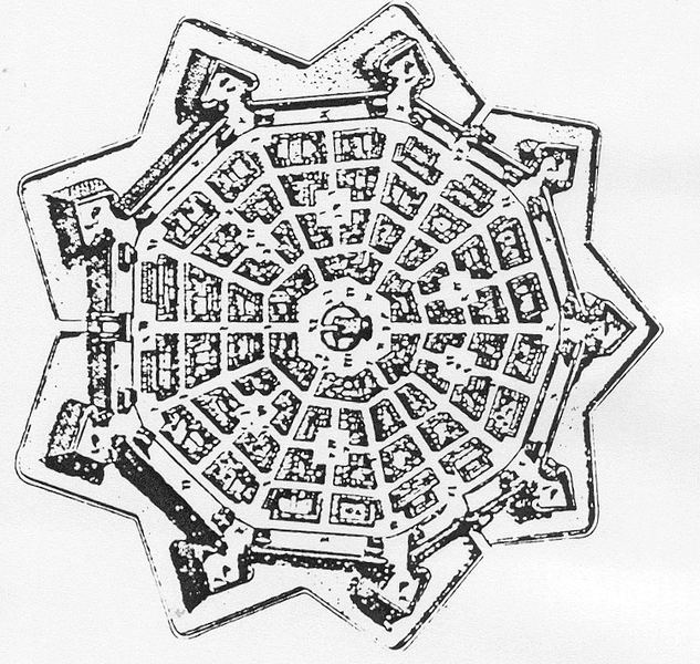
Masterplan of Palmanova. source: www.skyscrapercity.com
Palmanova, now a very picturesque small Italian town, was once build as a fortress town in the Friuli region. The region of Friuli was under Venetian rule since 1470. In this period there was an enduring threat for attacks from the Balkan by the Ottoman Turkish army, who wished to expand their territory. At the end of the 15th century there were no less than seven raids. Furthermore, after 1500, when the conflict between Venice and Austria was reopened, there was also a threat for invasions from the Austrian army. Apart from fortress Gradisca there were no other fortifications for the protection of the Friuli area. Only the walled city of Udine could give refugee for people during an invasion. In order to deal with the threat of invasions the Venice Senate ordered to build a fortress city in a strategic position of the Friulian plains: the junction between via Julia Augusta and the Strada Ungaresca. The city was named Palma in order to celebrate the 22 anniversary of Venice's victory against the Ottoman Turks at the battle of Lepanto.
Palmanova was designed according to the humanist theorists of the ideal city. The project was established by a group of engineers and military architects, which was led by Giulio Savorgnan. In the masterplan the town had the shape of a nine-point star with defensive walls. This shape was seen as the ultimate form for a walled city according to the military architects for reasons of protection. The walls of a this fort are run at angles which made it possible to establish overlapping fields of fire. Besides this the shape also reflected cosmological and humanist ideas.
Realisation
'Palmanova was supposed to be inhabited by self-sustaining merchants, craftsmen, and farmers. However, despite the pristine conditions and elegant layout of the new city, no one chose to move there, and by 1622 Venice was forced to pardon criminals and offer them free building lots and materials if they would agree to settle the town. Thus began the forced settlement of this magnificent planned space, which remains lifeless to this day and is visited only by curious scholars of Renaissance cities and bored soldiers who are still posted there to guard the Italian frontier.' (Muir, Edward, The culture wars of the late Renaissance : skeptics, libertines, and opera, Cambridge 2007, p. 175.)

)
)
)