- A. Reijndorp, Like Bijlsma, Ivan Nio. Atlas Nieuwe Steden. De verstedelijking van de groeikernen, Haarlem/Rotterdam: trancity*valiz, 2012.
- A. Faludi, A.J. van der Valk, De groeikernen als hoekstenen van de Nederlandse ruimtelijke planningsdoctrine, Assen/Maastricht: Van Gorcum, 1990.
- Niek de Boer, Donald Lambert. Woonwijken: Nederlandse stedenbouw 1945-1985. Rotterdam: Uitgeverij 010, 1987.
- Martien de Vletter. De kritiese jaren zeventig, architectuur en stedenbouw in Nederland 1968-1982. Rotterdam: Uitgeverij 010, 2004.
- W.J. Pantus. Groeikernen in Nederland: Een studie naar stedenbouw en architectuur, Utrecht: Stichting Matrijs, 2012.
type of New Town:
> scale of autonomy
New-Town-in-Town
Satellite
New Town
Company Town
> client
Private Corporation
Public Corporation
> policy
Capital
Decentralization
Industrialization
Resettlement
Economic
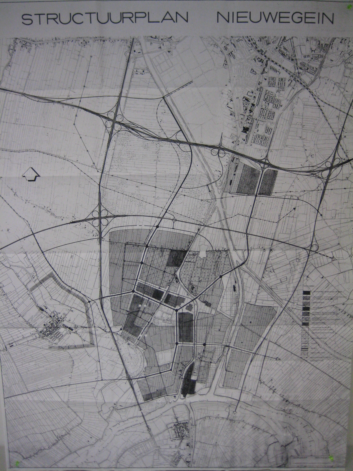
The original structure plan of the new town Nieuwegein. source: Archive of Jutphaas 1930-1971
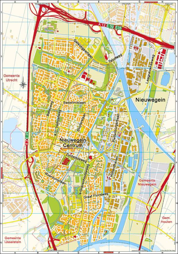
source: www.plategronden.nl
Reasons of its existents:
During the sixties it was clear that Utrecht was too small for the number of inhabitants of it's town. New living-areas had become designated for the house need. There was space free in the south area of Utrecht. The municipality Jutphaas and Vreeswijk were located in this area. These municipalities
joined together on the first of July 1971 to the municipality 'Nieuwegein'. Nieuwegein will function as an extension municipality for the city of Utrecht. By bringing the police force supervision at the A-12 road on the ground area of Utrecht, the border was changed by the first of January 1973.
Nieuwegein stood ca. 83 hectares ground between this Rijksweg, the Merwedekanaal and Amsterdam-Rijnkanaal. By 1 January 1989 once again a modification of the borders with the municipalities Ijselstijn, Linschoten, Utrecht and Vleuten-De Meern took place. This happened within the framework of a municipal division in the west of the province Utrecht.
Means of its excistents:
Within the framework of the spatial policy of the realm government concerning the edge city a number of municipalities to growth core was designated. The aim of these grow- cores and grow-cities was the relief of the population growth of the large cities in the area and the conservation of the so-called "green heart" in the edge city. To the beginning 80's Utrecht had a spectacular increase of population. From the year 1983 a reversal came. Inhabitants of the city left Utrecht to buy a larger house for the same in the outside-located growth cores. Nieuwegein count approximately 25,700 households. Of this 54.8% is buy, 33.4% social hiring, are 8.6% remaining hiring and 3.2% is unknown. With the percentage of 33.4% social hiring it lies against the average of the Netherlands. This is due to systematically arises of the city. By conditions clearly at the decision-making in 1971, a good social proportion has arisen. The social house file becomes for a major part by the Mitros looks after. The Mitros are of the largest social house construction society of the edge city.
Nieuwegein Absolute Relative
--------------------------------------------------------------------------
Sale 14054 54,8%
--------------------------------------------------------------------------
Social housing 8584 33,4%
--------------------------------------------------------------------------
Commercial rent 2203 8,6%
--------------------------------------------------------------------------
Unknown 826 3,2%
____________________________________________
Total 25667 100%
Biography:
Vreeswijk arose in the 10th century. On the possession list of Sint-Maarten in Utrecht report was made of the village Friezenwijk, Vreeswijk. The exact location of the village have not been confessed however. Beginning 14th century the core of the village moved to the direct surroundings of the river the Lek. Here in 1373 it was started with the construction of wooden lock in the Vaartse Rijn. At this place a lock is still present. The lock was built to link Utrecht with the Rijn.
The a rose of Jutphaas has not been exactly confessed. The first report of the village descends from the 11th century. The village was emerged around the church field to the 'Nedereindse' road. Up to the 17th century Jutphaas was a village with less concentrated buildings. By the increase of the inhabitants the municipality Jutphaas was formed. As the population increased further the areas Hoog, Laag a rose and West-Raven. By the aggregation of both municipalities the northern area Hoog-Raven was joined at Utrecht. This area until now is a built-up area in Utrecht.
On the First of July 1971 these two municipalities aggrigated to the growthcore 'Nieuwegein'.
The name comes of the former settlement called Geyne. This settlement in 1294 has got its town rights, but in 1333 it was demolished in a war between the bishop of Utrecht and the earl of the Netherlands. Today 'Huis Oudegein' only reminds still to this time. After the governing boards of Vreeswijk and Jutphaas had some time debated concerning the name of the new city, it was decided to call the city to this old settlement.
(Discussion kept concerning the structure plan Nieuwegein on 10 October 1968 in building. the "lantaern" at Jutphaas. Spoken by Dr. Kuiper: "The plan aims at the areas of the municipality of ca. 50.000 to 55.000 inhabitants.
The new municipality will get a clearly new centre, where the existing rural bowls will obtain a character of centres or district centres.")

)