|
|
Farsta, Sweden, Europe |
|
|
|
|
|
|
|
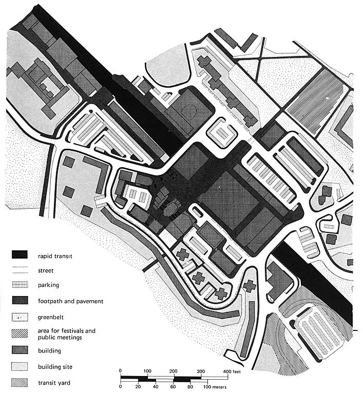
Farsta in the southern Stockholm consists of the seven city districts of Fagersjö, Farsta, Farsta Strand, Gubbängen, Hökarängen, Larsboda, and Sköndal. After the inauguration of Vällingby, the first new town combining work, housing, and centre in November 1954, it took almost another five years to complete Farsta, the next ABC new town (Arbeta, Bostad, Centrum). Development of the latter followed the general pattern of Vällingby, however, with a series of significant differences. For political and economic reasons, Farsta came into being as a product of private enterprise with the city as overseer, while Vällingby was an almost altogether public project. Some critics have argued that Farsta ignored to learn from the lessons of Vällingby and catered less for its inhabitants than the former new town. As David Pass writes: The disparate population densities of the city districts in the Farsta Development Area no doubt reflect local variations in terrain and other technical obstacles; when compared with the Vällingby Development Area, though, they suggest a less highly developed municipal housing commitment. Still, Farsta belongs to the older generation in the family tree of Stockholm satellites predating the Brutalist, prefabricated architecture of the Million Program. Although, geological investigations and initial planning by amongst others Stockholms principal city planner Sven Markelius already began in 1948, only little happened at the Farsta site before 1953. Construction of apartment houses in Gubbängen and a small enclave of one-family homes in Sköndal were initiated in 1940s. However, only by 1953 the city planning office of Stockholm decided that the transit line would include the periphery towards the south - the Tunnelbana reached Farsta as late as fall 1958. Housing areas in Farsta are usually dense since most of the city districts are generous with land for greenbelts and other uses like commerce, shopping, light industry, and transportation. While land use in the community centre is mainly reserved for residences and various services (schools, transport, shops, etc.), the southern Gubbängen consists of a major greenbelt. Primarily residential, Hökarängen is considerately more developed than Gubbängen, however, land use in Farsta is otherwise similar. With a high population density Hökarängen was planned as an area of humbly equipped small-scale housing units for large families with little income. Meanwhile some improvements have been made. At Sköndal there are single-family houses as well as multi-storey rental apartments. Except for land reserved for industry and housing, a large portion of this city district is left as open space. As a result of a highly differentiated land use, the population of Farsta Centre is packed into high-rise apartment houses up to sixteen stories tall. Originally, the vision of the Farsta Centre was for it to serve as a community centre for the entire development area. Most residential construction in the centre occurred between 1956 and 1960 and it is well connected with a railroad station, a transit station, a network of busses, and roads towards north-south as well as east-west. The character of development at Farsta Strand is almost exclusively residential. From the beginning, fewer residents in Farsta work locally and walk to work than in its big brother Vällingby. In 2004 the total population was 45,463 on an area of 15.40 km2, which makes a density of 2,952.14/km2. Farsta is connected to central Stockholm via the Green line of the Tunnelbana (metro) at a distance of approx. 8 km.
source: Signe Sophie Boeggild |
|
2008 - 2024 disclaimer
|
