- 'Planning Rethinking Ciudad Guayana', Lisa Peattie, 1987
- 'Build a Mill, Build a City, Build a School. Industrialization, Urbanization and Education in Ciudad Guayan, Venezuela', Noel F. McGinn and Russell G. Davids, 1969
- 'Planning a Pluralist City. Conflicting Realities in Ciudad Guayana', Donald Appleyard, 1976
- Clara Irazábal, "A Planned City Comes of Age: Rethinking Ciudad Guayana Today" in: 'Journal of Latin American Geography", vol 3, no. 1, 2004
type of New Town:
> scale of autonomy
New-Town-in-Town
Satellite
New Town
Company Town
> client
Private Corporation
Public Corporation
> policy
Capital
Decentralization
Industrialization
Resettlement
Economic
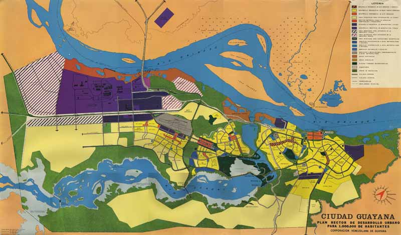
Established by the Venezuelan Government in the early 1960's, Ciudad Guayana was the first of the new cities in Venezuela and meant to be a pilot strategy for the economic decentralization of the country. It is located at the confluence of the rivers Orinoco and Caroni in an area extraordinarily rich in natural resources and was intended to be formed by the union of the old town of San Féix and the new town Puerto Ordaz, founded in 1952 as the headquarters of the Orinoco Mining Company. In the plan several smaller cities were united into one massive residential, industrial and commercial area. The city became a major development area with a steel complex, two aluminum plants, a tractor factory, bauxite and gold mining, a timber reserve and the Guri hydroelectric project. Guri dam has been the world's second biggest hydroelectric power station. For formulating an economic strategy of the region the government set up Corporacion Venezuela de Guayana (CVG). For the analysis and planning CGV worked together with Massachusetts Institute of Technology and Harvard University. The city plan has a commercial and civic center at a high point (Alta Vista) between the steel mill in the west and the community of San Felix in the east. A recreational and cultural centre was planned on a location in the river Caroni. The residential areas were planned to develop from San Felix to the west, as the city would grew. Puerto Ordaz by Sert (TPA) was laid out for the US Steel Company on the banks of the Orinoco River (1951-1953). The leader of the interdisciplinary team from the MIT-Harvard Joint Center for Urban Studies - consisting of land-use planners, economists, sociologists, anthropologists, and other social scientists -Lloyd Rodwin, in his 1956 publication "British New Towns Policy" criticized Howard's Garden Cities for being utopian. His aim for Ciudad Guayana was a more integrated planning. The collaboration between the CVG and the Joint Center was problematic. The Joint Center was testing theories of urban development and sought to plan an ideal city that would introduce modern planning to Venezuela. In the CVG's view lacking understanding for the local setting, their approach was disliked, and many of their planning suggestions were never realized. Ciudad Guyana is a site of interaction between national and international economic interests and a product of the smash-up of local Venezuelan and foreign urban planning initiatives. The projected economic and population growth did not match what happened: Instead of professionals, private investors, small industries, and commercial entrepreneurs, rural unskilled migrants came to the city, attracted by the job opportunities in the growing industrial sector. Unable to offer enough work for all, the city divided economically and urbane into two; a skilled group working in the capital industry and living in the originally planned city and a poor group with marginal or no occupation establishing and settling in barrio areas. As the housing programs were not able to provide houses enough for all the people arriving in the city, people had to find homes themselves through unplanned settlements. By 1990 the government projected that the city, with its industrial complex and concentration of government services, would boast a population of one million before the end of the twentieth century.

)
)