- Beyme, Klaus von, Werner Durth, Niels Gutschow, Winfried Nerdinger and Thomas Topfsted, Neue Städte aus Ruinen. Deutscher Städtebau der Nachkriegszeit, München 1992.
- Dariu, Veronika, Der Architekt Gottfried Böhm, Bauten der sechziger Jahre, Düsseldorf 1988,71-80.
- Hall, Heribert, Köln. Seine Bauten, 1991.
- Kiedorf, Alexander, Köln. Ein Architekturführer, Berlin 1999.
- Kier, Hiltrud, Die Kölner Neustadt. Planung, Entstehung, Nutzung, Düsseldorf 1978.
- Kluyver, P., Nieuwe steden. Een verkenning van verstedelijkingsprocessen, Paris/Amsterdam 1970.
- Linke, Volkert, Vorort, Satelliten- und Trabantenstadt. Ein Beitrag zu Entwicklungstendenzen und zur Terminologie von kernstadtabhängigen Siedlungen, dargestellt an den Beispielen Köln-Chorweiler, Hamburg-Norderstedt, Bielefeld-Sennestadt und Köln-Erfstadt, (diss.) Köln 1977.
- Ludmann, Harald en Joachim Riedel, Neue Stadt Köln-Chorweiler, Stuttgart 1967.
- Schäfke, Das neue Köln, Köln 1994.
- Theleman, M., and D. Wiktorin, ‘Die ‘Neue Stadt’ Köln-Chorweiler. Gartenstadt oder Betonwüste’, Köln und der Kölner Raum. Ein geographischer Exkursionsführer. Teil 1: Stadt und Umland, Cologne, 89-98.
type of New Town:
> scale of autonomy
New-Town-in-Town
Satellite
New Town
Company Town
> client
Private Corporation
Public Corporation
> policy
Capital
Decentralization
Industrialization
Resettlement
Economic
source: P. Kluyver, 'Nieuwe Steden, een verkenning van verstedelijkingsprocessen', Amsterdam 1971
Introduction
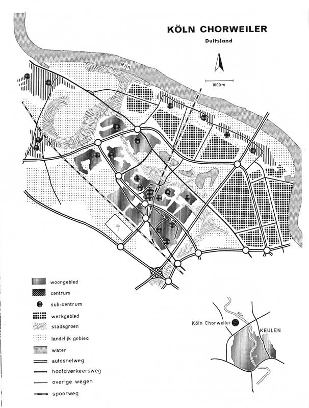
Köln-Chorweiler was developed as a satellite town thirty kilometres north of Köln near the Rhine. After World War II the city of Köln struggled with a housing shortage, due to severe bombardments and later population growth due to economic improvement (between 1950 and 1960 the population had more than doubled). The industries of Köln were looking for a new settlement because of new emission restraints. The urban planning department decided in 1957 to create a new settlement to the north of the city with a population of 80,000 to 100,000 inhabitants. This location was chosen because of the good infrastructural connections, the present highways to Köln-Neuss and Leverkusen-Aachen, the closeness of the harbours of Heihl and Olhaven, the airport and the closeness of the Rhine. The present villages, Rheinkassel, Langel, Pesch, Volkhoven, Weiler, Fühlingen, Heimersdorf, Seeberg, Chorweiler, Worringen, Roggendorfs, Ausweiler and Esch, with a total population of 15,000 in 1958, were incorporated.
Urban plan and design
Already in 1923 the German architect of the Deutsche Werkbund Fritz Schumacher (1869-1947) designed a master plan for Köln with an expansion to the north. After the war the plan became the manual for city planning. A group of architects together with the public departments designed a linear structure along the Rhine. After extensive topographical research this form seemed to be the best option. The industrial area was located on the riverside and the residences to the west of the industry, separated by a recreational zone with lakes and sport facilities. The residential part was divided into nine quarters with 400 to almost 3,000 inhabitants. The German architect Hans Schilling (1921-2009) designed the centre with cultural facilities, a mix of houses (1,200), offices (30,000) and public services, but most of the planned offices have not been built. With the assumption that more than 70% of the inhabitants would work outside the city, an elaborate system with a ring road around the residential districts, linked to Bundesstrasse 9 and the highways to Düsseldorf, Wuppertal, Hannover, Berlin and to Bonn, Frankfurt and Aachen, was laid out. With these connections it was possible to reach Köln in only twenty minutes. The railway was laid out along the western side of the city and also a metro (U-Bahn) and a bus line were constructed. In the city itself the pedestrians and cyclists had their own paths without intersections with other traffic. Cars were parked in underground garages so that they would not bother the inhabitants. Besides infrastructure much attention was paid to green spaces in order to make the city attractive.
Realization
The land was purchased by the reallocation of local landowners. The construction was planned in several phases from south to north. The construction started in the quarters of Niemersdorf (1960-1965), Seeberg-Süd (1962-1969) and Seeberg-Nord (1969-1977). In the second phase Chorweiler-Centre and Chorweiler-Nord were to be built. In the third phase Blumenberg was built and in the last phase the buildings of the old villages were restored. The southern districts consisted mainly of four-storey high apartment buildings, the centre had a maximum of thirty storeys and to the north the building height was reduced. The first quarters were mainly built with high-rise flats and rectangular slabs. In the seventies the style changed. At Seeberg (1969-1977) the social housing associations organised a competition between West German architects to design modern housing types. The associations tried to meet the demands and desires of the (future) inhabitants with a mix of housing types.
Present situation
In the eighties Köln-Chorweiler lost its attractiveness for a great part of the population. The middle class moved out and mostly immigrants moved in. The city was dominated by vacancy, crime and unemployment. To end this situation the municipality started a redevelopment program (1987-1989 and 1989-1997). The reconstruction consisted of reducing the large-scale infrastructure, the improvement of apartments and the building of youth centres. To stimulate the employment a Handwerkshof was built for handcraft and job preparation. In 2008 Köln-Chorweiler had a population of around 13,000 inhabitants on a surface of 1.9 square kilometres. Köln-Chorweiler was developed as an independent municipality in a very short time and with an overall concept, but nowadays it has become a part of the whole city structure of Köln.