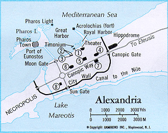
map of Alexandria
source: http://www.christiancdrom
.com/maps/Map%20-%20Alexa
ndria.bmp (accessed :
04-10-2010)
Alexandria's hippodamian
plan
source: http://gtae.users.btopenw
orld.com/alexandria.htm
(accessed : 04-10-2010)
|
Next to the Nile, and before the advent of Alexander the Great, already existed a city called Naucratis, officially turned over to the Greeks in 570 BCE. Its significance lied in the fact that due to its location it was a large market port, financially collaborating with nine eastern Greek cities. Alexander the Great wanting to replace Naucratis with a largest Hellenistic center, part of his empire, and create a link between Greece and the Nile Valley, ordered the establishment of Alexandria in 332 BCE. In order to be distinguished from the rest of his namesake cities, it was known as Alexandrea ad Aegyptum (Ancient Greek : Ἀλεξάνδρεια ἡ κατ' Αἴγυπτον).
Alexander assigned Deinocrates of Rhodes for the urban planning and Sostratus of Cnidus as the architect. Deinocrates is now the second ancient Greek reknown planner, after Hippodamus of Miletus. At the beginning he was an architect mainly known for the reconstruction of the temple of Artemis - one of the seven wonders of the world - in collaboration with Paeonius of Ephesus, until he approached Alexander the Great, suggesting to build for him a city on Mount Athos in Greece. His proposal was rejected by Alexander, who, however, admired the outline appointing him director of the urban planning of Alexandria. Sostratus, on the other hand, would be the architect responsible for one of the seven wonders of the world, the lighthouse of Alexandria, on the island of Pharos.
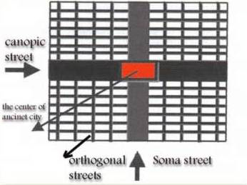
Deinocrates helped by Cleomenes of Naucratis, nomarch of the arabian district of Egypt, and Crates of Olynthus, hydraulic engineer responsible for the waterworks, laid out the city plan based on the hippodamian model, widely used in Hellenistic period. This model was the work of Hippodamus of Miletus, a pioneer of urban planning according to Aristotle (Politics II : VIII).1 What Hippodamus did, was to try to draw up an ideal city, by firstly understanding the connections between the functional problems of the cities to the types of the administration systems. He resulted in a grid plan comprising broad, straight streets cutting each other in such a way as to create rectangles, and, in the center, a wide open area which could gradually evolve to an agora space. His ideal city, which was divided in three space categories, sacred, public and private, addressed to a society of almost 50.000 people whose men would be classified in soldiers, artisans, and husbandmen. The hippodamian model was used by Alexander the Great for most of his cities.
Alexandria was built in close proximity to an existing small city named Rhacotis which provided labor, accessibility from large ships and water supply through a canal. The most important characteristics of the city's plan apart from the grid, were its two main axes : the east-west Canopic way and the Soma street, as shown in the illustration 2, which are claimed to have had a width of 25 to 70 meters, while marble colonnades on the sideways reinforced their linearity.
The Canopic way connected the Necropolis and the Canopic Gate, while the Soma street stretched from the Moon to the Sun Gate. The Gates were part of the fortification structure of the city which was claimed to be defined by Alexander himself, along with its borders, size and location of important public buildings. The urban enclosure of Alexandria with a total wall length of 15.8 km was then the third largest one after Athens' and Syracuse's. Within the wall, the archaeological findings show that the urban grid was rotated 25 degrees off the main axes, on purpose, allowing the city to be exposed to northerly winds. Another important element of the city's plan and infrastructural construction, was the causeway built to connect the Pharos island to the main city area, designed also by Deinocrates.
While Alexandria followed the Hellenistic urban pattern of the gridiron plan, the blocks designed for the city were of slightly different size, being, according to findings, ten meters smaller than the Hellenic typical block. The original city plan stretched in an estimated area of 840 hectares whilst the population, during the Hellenistic period may have varied between 75.000 to 500.000.
While Alexander had great plans for his namesake city, he didn't manage to visit it again. However, the city, during its Hellenistic period (332 BCE - 30 BCE), came up to his expectations, becoming the most important Greek city of Egypt and a large center of commerce between Europe and the Arabian and Indian east. Its most important period was that of the Ptolemaic dynasty (305 BCE - 30 BCE) with an emphasis on infrastructural and cultural development.
Alexandria's history is divided in many periods and it was influenced by various civilizations and historical events. As mentioned above, the Hellenistic period ended in 30 BCE and it was followed by Roman Annexation and the Byzantine period (30 BCE - 641 CE), Early Islamic Period (639 CE - 1250 CE), Mamluk Sultanate of Egypt (1250-1517), the Ottomans and Muhammad 'Ali Pasha (1517-1882) and the final period of British Occupation, Egyptian Independence, and Contemporary Alexandria (1882-2009).
There has been great effort in order to explore the history of Alexandria through excavations. Due to many wars and earthquake subsidence, part of the ancient city has been lost. But still, the lack of space for excavation and the fact that part of the city lies underwater, create many obstacles. The new city is built on top of the ancient one, and this also raises the cost of excavations, despite the help by the local Archaeological Society and many individual Greeks.
NOTES :
1. MIT [Massachusetts Institute of Technology], The Internet Classics Archive (1994), Aristotle, 'Politics', written 350 BCE, translated by Benjamin Jowett. Online available from : http://classics.mit.edu/Aristotle/politics.html (accessed : 4th October 2010)
source: 1. 'Alexandria, Guide to its history and Ancient Monuments', Copyright Diane Day 2001-2006. Online available from : http://gtae.users.btopenworld.com/alexandria.htm (accessed : 4th October 2010)
2. Bible Maps for the complete Christian Collection. Online available from : http://www.christiancdrom.com/maps.html (accessed : 4th October 2010)
3. MIT (Massachusetts Institute of Technology), ArchNet [Islamic Architecture Community] Digital Library, 'Alexandria'. Online available from : http://archnet.org/library/places/one-place.jsp?place_id=1455&order_by=title&showdescription=1 (accessed : 4th October 2010)
4. MIT [Massachusetts Institute of Technology], The Internet Classics Archive (1994), Aristotle, 'Politics', written 350 BCE, translated by Benjamin Jowett. Online available from : http://classics.mit.edu/Aristotle/politics.html (accessed : 4th October 2010)
5. Wikipedia, vocabulary entry : Alexandria (accessed : 4th October 2010)
6. Wikipedia, vocabulary entry : Dinocrates (accessed : 4th October 2010)
7. Wikipedia, vocabulary entry : Naucratis (accessed : 4th October 2010)
8. Wikipedia, vocabulary entry : Sostratus of Cnidus (accessed : 4th October 2010)
9. The Princeton Encyclopedia of Classical Sites, Perseus Digital Library, ALEXANDRIA Egypt. [online]. Princeton, N.J. Princeton University Press 1976. Online available from : http://icarus.umkc.edu/sandbox/perseus/pecs/page.167.a.php (accessed : 4th October 2010) |

)
)