This short read provides a brief review of my graduation thesis: Farming Guangming: Articulating agricultural landscape and new town development for the “Green City” Guangming in Shenzhen. My thesis questions the current urban development and planning practices when dealing with agriculture in metropolitan areas, and argues that being an indispensable part of the urban system, the agricultural landscape should be incorporated in the urban development and planning system to achieve integrated city regions, especially in rapidly urbanizing regions with a long agricultural tradition like coastal China.

Observation
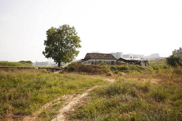
I met a young fish farmer on my first visit to Guangming on November 26, 2013. He lived in a traditional-style house surrounded by weeds, far away from other settlements, with two dogs and several free-range chickens (figure 1). The scene reminded me of the “retreat away from the world” described in ancient Chinese literature.
However, my romantic feeling about the place vanished during our conversation. His livelihood relies on two ponds in front of his house, but his business is almost over. He said the area covered by weeds used to be agricultural land for fishery and growing vegetables, cultivated by several households. Two years ago, the municipality claimed that these farming activities were illegal and removed the farmers without any compensation. The land was then consolidated, with the aim to attract investments from farming enterprises. It remained vacant till the day of my visit.
New town development on agricultural landscape
Guangming used to be one of the most important agricultural bases for Shenzhen and Hong Kong since the 1980s. Most of the open spaces were reserved for agricultural use. The situation began to change when a station of the high-speed railway connecting Guangzhou and Hong Kong was planned in the southeastern part of the region. In 2007, the Shenzhen government founded Guangming New District to make use of this opportunity. The new town is now regarded as a strategic location for urban intensification and upgrading Shenzhen’s industry to be more knowledge-based. The most important spatial guidelines for the new town development are the comprehensive master plan of Guangming (2007-2020) and the Ecological Control Lines (ECL), which is set up by the Shenzhen municipality to preserve nearly 50% of Shenzhen’s land area from urbanization.

However, my research shows that due to a lack of knowledge on existing agricultural practices, the new town plans have already heavily influenced the lives of local farmers and ecosystem performance. The story of the fish farmer mentioned above is a result of the modernization of agriculture promoted by the government within the ECL, which pays little attention to development opportunities of local communities. In fact, there is a lack of overall planning for development in the ECL, which results in declining rural communities and spatial fragmentation in the countryside.
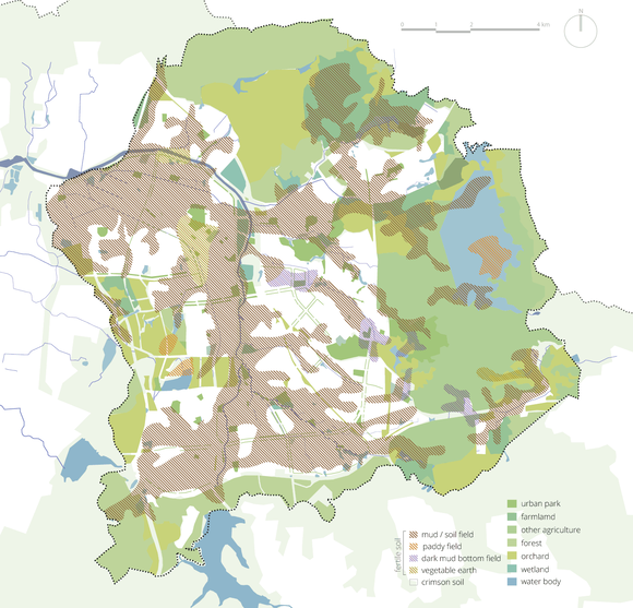
Outside the ECL, where urban development is supposed to happen, farmers have been losing their farmland more rapidly as a result of the construction of urban grids. The new grid structure doesn’t pay (enough) attention to the original landscape structure including water system, soil types and the coherent former relationship between human settlements, nature and agriculture (figure 2). The installment of urban grids not only accelerates the loss of farmland in the urban areas, but also results in decreased biodiversity and increased environmental hazards because the new town development heavily relies on hard infrastructure.
Surprisingly enough, in response to the extensive loss of farmland, many small plots of arable land are utilized by local residents for subsistence agriculture. Such a phenomenon happens mostly in temporarily vacant land, such as in industrial areas, underneath the railway, in some urban neighborhoods, near or in the urban villages, even behind the high-speed railway station. The spontaneous farming activities turn leftover spaces into productive landscapes (figure 3). It implies a desire to farm from residents with a rural background in Guangming—a desire that is not included in the new town development plans.
Guiding transformation of agriculture
The ongoing development of Guangming indicates that the transformation of the agricultural landscape is inevitable. So the questions are not how to protect the agricultural land from transformation, but how to moderate the impact on farmers and the ecosystem, and even more importantly, how to transform agriculture in a more sustainable way.
The on-site analysis shows that the performance of agriculture is tightly linked to the livelihood of local farmers, the lifestyle of current residents, and the ecological conditions of the area. Based on this understanding, I propose a reinterpretation of the role of agriculture in new town development:
– Understanding the dynamics of the agricultural landscape will provide knowledge of the ecosystem and people’s adaptation to the environment. When the overall landscape structure can be preserved, local farmers and residents can use some agricultural land for temporary interventions like recreational amenities for surrounding communities.
– Agriculture can be introduced in open spaces in and around the urban areas to deliver social benefits for the new town in terms of recreational and educational amenities, community development and open space management. Besides, the agricultural landscape can also serve the ecosystem to tackle issues like biodiversity, flood buffer, water infiltration and urban heat moderation. To achieve these social and environmental benefits, urban agriculture should be integrated with other urban functions and agriculture practices should be environmentally friendly.
In this new scenario for the agricultural landscape in Guangming, I argue that agriculture in urban and peri-urban areas should not only be considered as an economic sector in the countryside that focuses on productivity, but that it also provides a livelihood for local communities and that it is a means of natural resource management to deliver public goods, which should be included in the planning of new town development.
Rethinking urban-rural relationship
The new perspective indicates that agriculture should not be confined to rural areas. It challenges the traditional way of considering the relationship between cities and the countryside, which is also reflected in the Ecology Control Lines in Shenzhen: cities are for urban development while the countryside should remain un-built and be used for agriculture. A clear line can be drawn between the two.
However, in today’s Chinese cities, the urban-rural boundary is already blurred in many ways: spatially, urban functions are not confined in urban areas as industrialization also happens in the countryside; socially, many migrants into cities still keep their rural identity and lifestyle; even in the field of agriculture, an agricultural enterprise may also be involved in tourism, real estate or research. These phenomena also indicate that urbanization has a great impact on the countryside and it is a challenge for the rural sectors to sustain cities with labor, food, environmental resilience, etc. With increasingly intense and complex interactions between cities and their surrounding landscapes, the division between urban and rural seems to be no longer productive. For instance in Guangming, it is difficult to integrate green spaces and urban agriculture in urban areas due to the ECLs that differentiate the city and the countryside.
In recent years, the urban-rural relationship has been reformulated as the relationship between cities and their ecosystem services. This interpretation considers urban and rural as intimately connected sectors in a larger system and addresses functional linkages rather than spatial and sectorial division. Within this new framework, agriculture can be interpreted as part of the ecosystem, which serves the city with not only food, but also environmental and social goods.
Planning for rapid urban growth on agricultural landscape
The new understanding on agriculture and urban-rural relationship leads to revolutionary thinking on urban sustainability, which Forster and Escudero (2014) formulate as taking "city regions as landscapes for food, people, and nature", arguing that current city-oriented development should place more focus on urban-rural linkages to achieve sustainability. It requires a territorial integrated approach to manage dynamics and interactions of cities, agriculture and nature, which in my thesis is referred to as ‘landscape approach’. Nassauer (2013) points out that landscape can be used as a method and a medium for the ecological design of cities, as landscape integrates different environmental processes and is a shared experience of visible characteristics for different people.
Following theories and practices on the so-called landscape approach and urban agriculture, I propose guidelines for the rapid urban growth in Guangming, which include the following principles:
– Designing a continuous green network that links urban and rural open spaces, and respects agricultural and ecological conditions;
– Based on this green network, guiding rapid urbanization primarily on less environmental sensitive areas (or areas with less agricultural value);
– Classifying the green network and identifying characteristics for each zone based on potential agricultural activities, urban functions and natural conditions of the open spaces;
– Utilizing farming activities by residents and local farmers for community development while providing guidance for their spatial distribution and practices;
– Redefining the contents of the master plan and detailed plans, to facilitate the integration of infrastructure, green network, social system and ecosystem on smaller scales while ensuring mobility and connectivity on the regional scale.
Conclusion
In this project, agriculture is considered as a medium that links people, nature and food with new town development. I argue that the integration of the existing agricultural landscape in urban planning helps to achieve a more integrated landscape management of the city region: it improves the quality of open spaces, strengthens the characteristics of the countryside, balances the development of urban and rural, provides knowledge of the ecosystem, and moderates the impact of new town development on local farmers.
But more importantly, the integration of agriculture provides us with a lens to examine our understanding of new town development and urban sustainability. With this lens, I question the ECL as an oversimplification of the intense and complex interactions between city and its surrounding landscape; I question the modernization of agriculture with no attention for local communities and the social value of agriculture; I question green spaces in the new town as they are costly and placeless; I question the master plan as it mainly focuses on regional mobility and does not pay enough attention to existing local networks. The recognition of the key role of agriculture in urban sustainability is just a starting point, which I believe will ultimately lead to new planning and management approaches for today’s cities.
Jiayao Liu graduated in 2014. As a student at MSc Urbanism of the Delft University of Technology she took part in “Shenzhen Scenarios 2.0 – Livability in Shenzhen” within the Complex Cities Studio. This studio is co-organized by INTI as part of the New New Towns program.
References
– Forster, T. & Escudero, A.G., City Regions as Landscapes for People, Food and
Nature, Washington, DC: EcoAgriculture Partners, on behalf of the Landscapes for People, food and Nature Initiative, 2014.
– Nassauer, J.I., “Landscape as Method and Medium for the Ecological Design of
Cities” in: Pickett, S.T.A., Cadenasso, M.L. & McGrath, B. (eds.) Resilience in
Ecology and Urban Design: Linking Theory and Practice for Sustainable Cities. Springer, 2013.


